EIGHT MINING PERMITS
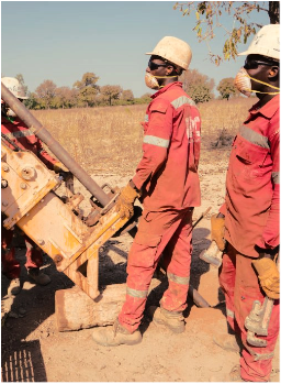
Exploration
. Exploration
Through our exploration programmes we intends to discover new mineral resource and convert mineral resources to mineral reserves to support the sustainability of our business.
Robex currently holds 8 exploitation and exploration permits, located in West Africa (Mali and Guinea), including 4 pure exploration licences.
In Mali, the property has a total surface area of c. 280km2 and consists of two parts: the Nampala and Mininko exploitation permit covering 16km2, and five exploration permits, covering c. 264km2. Two of Robex’s permits are situated in southern Mali (Kamasso and Gladié in aggregate c. 200km2), while the other two are located in the western part of the country (Sanoula and Diangounté, c. 32km2 each).
In Guinea, the Kiniero Gold Project is a 470km² exploitation and exploration land package that is in the Kouroussa Prefecture. It consists of the adjoining Kiniero License Area (exploitation) and the Mansounia License Area (exploration, in convertion to exploitation) hosting numerous deposits.
Subject to the Government of Guinea’s 15% interest, Robex also has the exclusive rights to acquire full ownership of the Mansounia license pursuant to a technical partnership agreement entered into with Penta Goldfields Company S.A subject to the satisfaction of the certain conditions precedent. Robex submitted to the Government of Guinea an application to convert the licenses into exploitation.


Do you Want to Know More about Us?
Robex is committed to responsible mining and delivering sustainable value to our employees, stakeholders and the communities in the countries we operate.
. South Mali
A complete reassessment of the geological configuration of these adjoining exploration properties was completed during 2022. Remote sensing and structural interpretation were completed using reprocessed airborne magnetic, and radiometric data, LandSat imagery, electromagnetic data, high resolution panchromatic satellite imagery and Sentinel-2 DEM data to create a single contiguous geological interpretation across all license areas.
Kamasso
The project includes the Kamasso exploration permits covering 100 km². Robex owns 100% of the permit and a 1% NSR is liable. It is located about 74 km southwest of Sikasso and 35 km south of Niéna village, which is accessible via the Nampala mine trail. In the prospecting Sikoro area, the geochemical anomaly is combined with an induced polarization anomaly. This gold anomaly is located on the southern extension of the stratigraphic and structural sequence where the Nampala deposit is. In 2009, 700 meters of drilling were completed and show a rooting under the surface of the soil anomaly.
The Kamasso permit offers very interesting prospects. It is located on the southern extension of the stratigraphic and structural sequence in which the Nampala deposit (Mininko) is located. It is located a few kilometers from Nampala. Exploration work previously carried out had helped to identify several geochemical anomalies in soils including the Sikoro, as well as those of Kadjila and Sirakoroni confirmed by wells and short-destructive surveys. The completion of a geological map using aerial and satellite images and an airborne geophysical survey of the Sysmine project in the territory of the Kamasso permit had also showed the continuation of large structures of the Nampala anomaly (Mininko permit) defined by faulting and fracture networks. Geochemical and geophysical studies have been planned on this property to determine drilling sites conducive to discoveries that may lead to future exploitation.
The region of the permit has been explored in detail since 1980, and soil geochemistry, geology, geophysics, and surveys revealed potential areas for exploration. The work has defined several gold targets, one of which became the Nampala deposit. Geochemical and geophysical studies have been planned on this property to determine drilling sites conducive to discoveries that may lead to future exploitation.
Gladié
The project includes the Gladié exploration permits covering 52 km². The geomorphological study revealed that the perimeter of the Gladié permit corresponds to a vast plain strewn with low, isolated mounds and wide, lateritic plateaus with gentle slopes on the whole. The compilation work made it possible to detect 16 soil anomalies that coincide perfectly with arsenic anomalies, although all of these anomalies are affected by an area with shearing in the northeast-southwesterly direction. The AC drilling sites led to results close to Nampala, with mineralized intervals between 0.2 g/t and 1.2 g/t.
The Gladié permit is very strategic as it covers the same kind of deposit as Nampala and is contiguous with the Mininko and Kamasso permits. The ore extracted from this permit could be processed in the same plant. It complements the existing permits to provide the ideal coverage of the existing deposit in relation to the work carried out by the previous owners. The Company intends to assess the exploration work at an opportune time in order to confirm.
Mininko
The project includes the Mininko exploration permits covering 62 km². Robex owns 100% of the permit and a 1% NSR is liable. It is on this property that the Nampala mine is located. It is located around 57 km to the southwest of the town of Sikasso and 21 km south of Niéna village, which is accessible via the trail from the Nampala mine. Geologically, it is located in the South Mali window, in the inferior Proterozoic age Birrimian bedrock, where the Syama, Morilla, and Nampala gold deposits were found. The project includes the operation permit of the Nampala deposit, and is located 35 km north-northeast of the Syama deposit and 92 km southwest of the Morilla deposit.
The region of the permit has been explored in detail since 1980, and soil geochemistry, geology, geophysics, and surveys revealed potential areas for exploration. The work has defined several gold targets, one of which became the Nampala deposit. Geochemical and geophysical studies have been planned on this property to determine drilling sites conducive to discoveries that may lead to future exploitation.
Diangounté-Nord
The project includes the Diangounté licence, which covers 52.14 km2. Robex owns 100% of the permit. It is located around 90km SSW of the city of Kaye and 30km SSW of the village of Sadiola, which is accessible by trails. Geologically, it is located in the northern part of the Kédougou Kéniéba window, in the inferior Proterozoic age Birrimian bedrock, which can be found in the central and northern part of the gold deposits of Sadiola, Loulo and Tabakoto. The project is located 30km SSW of the Sadiola deposit.
The licensed area has been explored in detail since the 90s. The geochemistry soil work, geophysics, and well surveys revealed several gold targets. This project encompasses the regional gold geochemical anomaly, La Corne (Klöckner-1989). This regional anomaly is similar to those that led, among other things, to the discovery of the Sadiola deposit. Subsequently, detailed geochemical work helped define a circular anomaly covering 8 km2.
. West Mali
Permit- scale exploration of both properties has recently been completed. This program included recalculation and interpretation of airborne magnetic and radiometric data, sourcing recent panchromatic high resolution satellite imagery and Sentenial-2 DEM data and completing a detailed BLEG gold-in-soil sampling campaign over both permits. In 2022, the work program has included RC drilling exploration (ongoing) coupled with surface mapping and sampling programs.
Sanoula
The project includes the Sanoula exploration permit covering 31.5 km2. Robex owns 100% of the permit and a 1% NSR is liable. It is located around 58 km north-northwest of the town of Kenieba and 120 km south of the city of Kaye, which is accessible by trails. Geologically, it is located in the northern part of the Kédougou Kéniéba window, in the inferior Proterozoic age Birrimian bedrock, which can be found in the central and northern part of the gold deposits of Sadiola, Loulo and Tabakoto. The project is located on the Senegalese-Malian Accident (ASM), which marks the boundary between the Kofi Formation to the east and the Kéniébandi Formation to the west, and is located between the Sadiola, 56 km north-northwest, and Loulo, 26 km south-southeast, deposits.
The region of the permit has been explored in detail since 2000, and soil geochemistry, geophysics, geology, and surveys have found a linear gold mineralized area. The area was drilled in 2006 and 2007 following the discovery of a geochemical anomaly associated with a resistivity anomaly. A total of 966 meters was drilled; the mineralization intersection is contained in a highly distorted sedimentary tourmaline formation. Gold occurs mainly in strongly dipped pyritized quartz veins, in moderately silicified tourmaline-enclosed rock. This type of gold mineralization characterizes the Loulo deposit.

